
Skip to content
Gloucester County Amateur Radio Club

Gloucester County Amateur Radio Club

Skunkworks Advanced Project Team

Menu
  • Home
  • Club Activities
    • WSPR Activities
      • Current WSPR & Band Report
      • Clubhouse WSPR Station Report
      • WSPR Network Monthly Reports
        • July 2026
        • June 2026
        • May 2026
        • April 2026
      • WSPR Field Day 2026 — Propagation Comparison
    • Satellite Activities
      • Saturday Clubhouse Satellite Opportunities
      • Weekly Satellite Report
      • Upcoming ISS APRS Activities
      • Upcoming ISS Viewing Opportunities
      • GOES 19 Weather Video
      • Current ISS SSTV Images
    • Recent DMR Activity
  • Clubhouse
    • Saturday Clubhouse Weather
    • The GCARC Clubhouse
    • Grounding Project
    • Networking Infrastructure
    • Work and Test Bench
    • Clubhouse Satellite Station
      • Satellite Rotator Controller
      • Satellite Station Remote Operation
    • SatNOGS Ground Station
    • Earth-Moon-Earth (EME)
    • Discovery Satellite Snooping Dish
    • GOES-19 Satellite Reception
    • Clubhouse Remote nRSP-ST Resource
    • Skunkworks GitHub Resource
    • ISS SSTV
    • NOAA Weather Fax
    • ADS-B
  • Technical Resources
    • Working Meteor Scatter at W2MMD
    • WSPR Network Resources
      • The TAPR WSPR Board for Dummies
      • Why Is My WSPR Signal 1500 Hz Off? — A Tale of Two Frequencies
      • GCARC WSPR Network — Project Description
      • GCARC WSPR Network — Technical Reference
      • GCARC WSPR Network — Band Selection Guide
      • GCARC WSPR Network — Analysis and Reporting
      • The GCARC WSPR Network — Member Q&A
    • DMR
      • What is a DMR Codeplug?
        • What Are DMR Channels?
        • What Are DMR Timeslots?
        • What is a Talkgroup in DMR?
        • What Are DMR Zones?
      • What is a DMR Hotspot?
      • Configuring DMR Hotspot for GCARC Talk Group
      • Connecting to the GCARC DMR TalkGroup with a Yaesu System Fusion Radio and a Hotspot
      • Using DM-1701 CPS Program
      • Open GD77 on Baofeng DM1701
      • Pi-based OpenGD77 Flasher: Bypassing Windows Driver Headaches
        • OpenGC77 Codeplug
    • Software-Defined Radios
      • Software Defined Radio Demystified
      • Installing an RTL-SDR on a Windows PC
      • SDR Tech Saturday Presentation January 2025
      • SDR Client Applications for Mac
      • Creating a PiAware Station to Track Airplanes
        • Installing PiAware Using the Prebuilt SD Card Image with Raspberry Pi Imager
        • Installing PiAware using Command Line Commands
    • Receiving ISS SSTV Images
    • Meshtastic
      • Getting Started with Meshtastic on 915 MHz
      • How to Join the GCARC Channel on Your Meshtastic Device Using a QR Code
      • Installing the Meshtastic CLI on a Windows PC
      • Window-Mounted 915 MHz Meshtastic Yagi Antenna Project
      • Meshtastic CLI Commands
    • Exploring Ham Radio Digital Modes: Packet Radio and WSJT-X
      • Packet Radio (AX.25) in Amateur Digital Communications
      • Exploring WSJT Digital Modes
    • BTECH UV-PRO Radio
      • Satellite Mode for the UV-PRO
    • TIDRADIO H3 Resources
      • TIDRADIO TD-H3 Transceiver: Comprehensive Briefing
      • Overview of Stock Firmware Menu System
      • Comparison of Stock TIDRADIO Firmware vs. nicFW V2 Firmware
    • Balloon Project
      • Balloon Launch – 2025-03-17
    • 3D Printed Projects
    • Tech Saturday Presentations
    • Receiving ISS HamTV
  • STEM Activities
    • STEM Club Weather
    • STEM Club Villanova Trip
    • STEM Club Satellite Pass Schedule
    • STEM Camp 2026
      • Calculator Skills — TI-84 Evo
  • Public Service
    • GCARC Planning Documents
      • Amateur Radio & Served Agency Integration
      • Building Served Agency Capability
      • The Ham Next Door
      • NIFOG Guide
      • AUXFOG Guide
    • GCARC Resources
      • Winlink VHF and HF Gateways
      • APRS Weather Reporting Station
    • AREDN Development
  • The Foundation
  • Blog
  • Contact

GCARC WSPR Daily Report — August 04, 2026

GCARC WSPR Propagation Report — August 04, 2026
📡

GCARC WSPR Propagation Report

Gloucester County Amateur Radio Club — Daily HF Analysis
All BandsAugust 04, 2026
Generated daily at 6:00 AM ET · Station data: past 7 days · Space weather: past 30 days · Prepared August 04, 2026 at 06:00 AM ETData: wspr.wb2mnfai.org · Space weather: NOAA SWPC
Right Now40m30m20m15m10mWWVDist vs SNRSpace Weather

⚡ Right Now — Which Bands Are Open?

August 04, 2026

Live readout of where GCARC’s participating stations are hearing receivers right now (last 60 minutes). If you’re thinking about firing up the rig, this tells you what propagation looks like this minute. Updates every 5 minutes from wspr.wb2mnfai.org.

Loading…
Connecting to live feed…

📶 Forty Meters — 40m

7 MHz · August 04, 2026
Band Conditions & Coverage

The 40-meter band continues to deliver reliable mid-latitude propagation despite poor daytime conditions, with the nighttime Fair rating supporting consistent transatlantic and transpacific openings. K2ZA and N2LQH both logged best-distance contacts to Australia—VK5ARG at 10,551 miles and 10,568 miles respectively—demonstrating that 40m remains viable for genuine DX work even under these space weather constraints (SFI 126, K-index 4). The band shows bimodal activity peaks: a strong nocturnal window centered around 02:00 UTC favoring long-path skywave to Europe and the South Pacific, and a secondary diurnal peak near 11:00–12:00 UTC supporting regional groundwave and short-skip propagation. K2ZA achieved 374 unique receivers across 7,909 spots with a 706-mile average distance, suggesting robust regional coverage with occasional DX breaks. KC2GYU’s superior spot density of 14,654 detections indicates exceptional transmitter stability or receiver network timing advantage, reaching 372 unique stations and posting a best-distance mark of 10,606 miles to VK5EI. N2LQH’s 5-watt signal penetrated to 495 unique receivers with 188 European stations captured, establishing this station as the primary European gateway despite lower power-normalized efficiency. KE2AQZ performed credibly at 100 milliwatts, earning 4,802 spots and reaching EA8BFK at 3,514 miles—a notable accomplishment for low-power operation and evidence of favorable propagation geometry toward the Canary Islands during midday UTC hours.

40m receiver map
40m receiver locations today. Lines connect each transmitting station to unique receivers. Circle size is proportional to spot count.
📊 Per-station detail for 40m (time-of-day chart, station results, station comparison, directional analysis) is on the GCARC group report: view 40m detail →

📶 Thirty Meters — 30m

10 MHz · August 04, 2026
Band Conditions & Coverage

Narrative not available.

30m receiver map
30m receiver locations today. Lines connect each transmitting station to unique receivers. Circle size is proportional to spot count.
📊 Per-station detail for 30m (time-of-day chart, station results, station comparison, directional analysis) is on the GCARC group report: view 30m detail →

📶 Twenty Meters — 20m

14 MHz · August 04, 2026
Band Conditions & Coverage

The 20-meter band exhibited Fair propagation conditions throughout the reporting period, with the 14 MHz frequency sustaining reliable trans-Atlantic and trans-Pacific skip. The band demonstrated classic characteristics for its solar cycle phase, with K2ZA leading the pack by total spots at 5,488 and maintaining the highest unique receiver count at 461, while achieving genuine intercontinental reach including VK5EI at 10,588 miles. KC2GYU’s 7,563 total spots represent the highest activity level despite running just 200 milliwatts, pointing to aggressive operating schedules that capitalized on the Fair day and night conditions equally. Peak UTC hours clustered around the night boundary, with K2ZA and W2LJR showing 01:00 UTC peaks typical of European morning openings on 20m, while KC2GYU and W2MMD peaked at 12:00 UTC suggesting better daytime propagation to their respective targets. The European receiver count of 144 for K2ZA underscores 20m’s particular strength for stateside-to-Europe contacts, though N2LQH’s 207 EU receivers on 5 watts demonstrate that power and antenna efficiency matter equally. Notable DX included multiple VK-series contacts reflecting long-path or near-vertical incidence-angle propagation, with best distances ranging from 10,588 to 11,797 miles—consistent with a K-index of 4 and A-index of 19 providing modest but workable conditions.

20m receiver map
20m receiver locations today. Lines connect each transmitting station to unique receivers. Circle size is proportional to spot count.
📊 Per-station detail for 20m (time-of-day chart, station results, station comparison, directional analysis) is on the GCARC group report: view 20m detail →

📶 Fifteen Meters — 15m

21 MHz · August 04, 2026
Band Conditions & Coverage

The fifteen-meter band continues to demonstrate reliable transequatorial and transatlantic propagation under Fair space weather conditions, with a solar flux index of 126 supporting consistent skip to both European and South Pacific regions. The four active stations collectively logged 6,029 spots across 152 to 279 unique receivers, establishing reliable paths to VK5ARG in Australia at distances exceeding 10,550 miles—a consistent achievement across all stations, suggesting well-established gray-line enhancement during the reporting period. Geographic coverage spans from domestic Northeast US reception through extensive European networks (6 to 137 receivers per station) and sporadic Pacific penetration, with peak activity clustering around 13:00 UTC for K2ZA and W2MMD, shifting to 15:00 UTC for the more efficient systems at KC2GYU and N2LQH. The K-index holding at 4 and A-index at 19 maintained stable ionospheric conditions without significant degradation, allowing sustained signal propagation particularly during daylight hours when F2 layer critical frequency remained favorable for 21 MHz skip. Average distances ranged from W2MMD’s modest 945 miles to N2LQH’s commanding 2,904 miles, reflecting both power deployment and antenna effectiveness, with KC2GYU’s 2,018-mile average from a quarter-watt input particularly noteworthy for efficiency.

15m receiver map
15m receiver locations today. Lines connect each transmitting station to unique receivers. Circle size is proportional to spot count.
📊 Per-station detail for 15m (time-of-day chart, station results, station comparison, directional analysis) is on the GCARC group report: view 15m detail →

📶 Ten Meters — 10m

28 MHz · August 04, 2026
Band Conditions & Coverage

Narrative not available.

10m receiver map
10m receiver locations today. Lines connect each transmitting station to unique receivers. Circle size is proportional to spot count.
📊 Per-station detail for 10m (time-of-day chart, station results, station comparison, directional analysis) is on the GCARC group report: view 10m detail →

📡 WWV Reference — NIST Time Station

August 04, 2026

WW0WWV is the NIST WWV/WWVH time-station beacon at Fort Collins, Colorado, transmitting WSPR continuously on multiple HF bands. Because its power, antenna and location are constant, it’s a steady benchmark for raw band openness — if WW0WWV is being heard widely on a band, that band is propagating. If it’s missing, the band is probably closed. P90 distance below is the same metric used in the per-band station tables on the live dashboard.

BandSpots (30d)P90 (mi)Best DXFirst Heard (UTC)Last Heard (UTC)
40m2,026,1681,557FR5DN2026/07/05 06:022026/08/04 05:58
30m1,911,9561,643FR5DN2026/07/05 06:022026/08/04 05:58
20m2,000,9711,643FR5DN2026/07/05 06:022026/08/04 06:00
15m669,3281,603VK6XT2026/07/05 06:022026/08/04 05:56
10m355,6871,094VK5HW2026/07/05 06:022026/08/04 05:58
WWV P90 reach by band
WWV P90 reach by band — 30-day window. Higher bars = farther reliable propagation.
WWV activity by band
WWV activity by band — total spots over 30 days. A noisy band = high spot count.
WWV P90 by hour
P90 distance per UTC hour by band — shows when each band is open. Bands rise during their propagation windows; flat-low = closed.
WWV spots by hour
Spots per UTC hour by band — receivers actively hearing WWV. Activity tracks when receivers tune in plus when the band is open.

P90 = 90th-percentile receiver distance — what you can reliably reach, ignoring the rare lucky DX. Best-DX callsign is the receiver that heard WW0WWV from the greatest distance over the last 30 days. Hourly charts cover the most recent 24-hour window.

☀️ Space Weather

August 04, 2026
Solar & Geomagnetic Conditions

Solar flux values of 126 are providing modest ionospheric support today, with the 104 sunspots contributing a moderate level of solar activity that should sustain reasonable F-layer density. This SFI reading is slightly above the historical average and is sufficient to keep the higher frequency bands open during daylight hours, particularly on 20 and 15 meters where fair conditions are forecast for both day and night periods. The 10-meter band, however, shows more variability with fair daytime propagation but poor conditions expected after sunset, suggesting that HF operators chasing DX should focus their 10-meter efforts during morning and afternoon windows rather than expecting extended evening openings. While these solar conditions won’t produce the spectacular skip distances or signal strengths associated with more active solar periods, they should provide consistent enough ionization for routine regional and moderate-distance communications across the upper HF bands.

The geomagnetic field is currently ACTIVE with a K-index of 4 and an A-index of 19, indicating moderate disturbance that will degrade propagation on the lower frequency bands and particularly impact long-distance paths toward the poles and across the Atlantic. A solar wind speed of 371.0 kilometers per second is elevated and contributing to this active geomagnetic state, which typically suppresses the D-layer absorption that affects 40 and 80 meters during daylight hours. The NOAA forecast showing poor daytime conditions on 80 and 40 meters reflects this solar wind influence, while the fair nighttime conditions on these same bands suggest that operators should expect brief windows of improved propagation after local sunset as the auroral oval activity patterns shift. Transatlantic and northern European paths will likely be significantly challenged today due to this moderate geomagnetic disturbance, making them poor choices for DX attempts unless operators are willing to accept reduced signal reports and difficult copy.

For today’s operations, the 30 and 20-meter bands represent the most reliable DX performers with fair conditions predicted around the clock, making them the primary focus for serious propagation work across both day and night. The 15-meter band also maintains fair daytime and nighttime conditions, offering another viable path for mid-range and some longer-distance contacts, though operators should be prepared for more variable results compared to 20 meters. Avoid the lower bands during daylight hours and save 80 and 40-meter efforts for after sunset when conditions transition to fair, and be aware that the currently active geomagnetic conditions mean that even nighttime lower-band propagation may deliver weaker signals than typical for the solar flux level. The elevated solar wind and moderate geomagnetic disturbance suggest that this is a day to focus on middle-HF band work rather than pursuing aggressive low-band or polar-path DX.
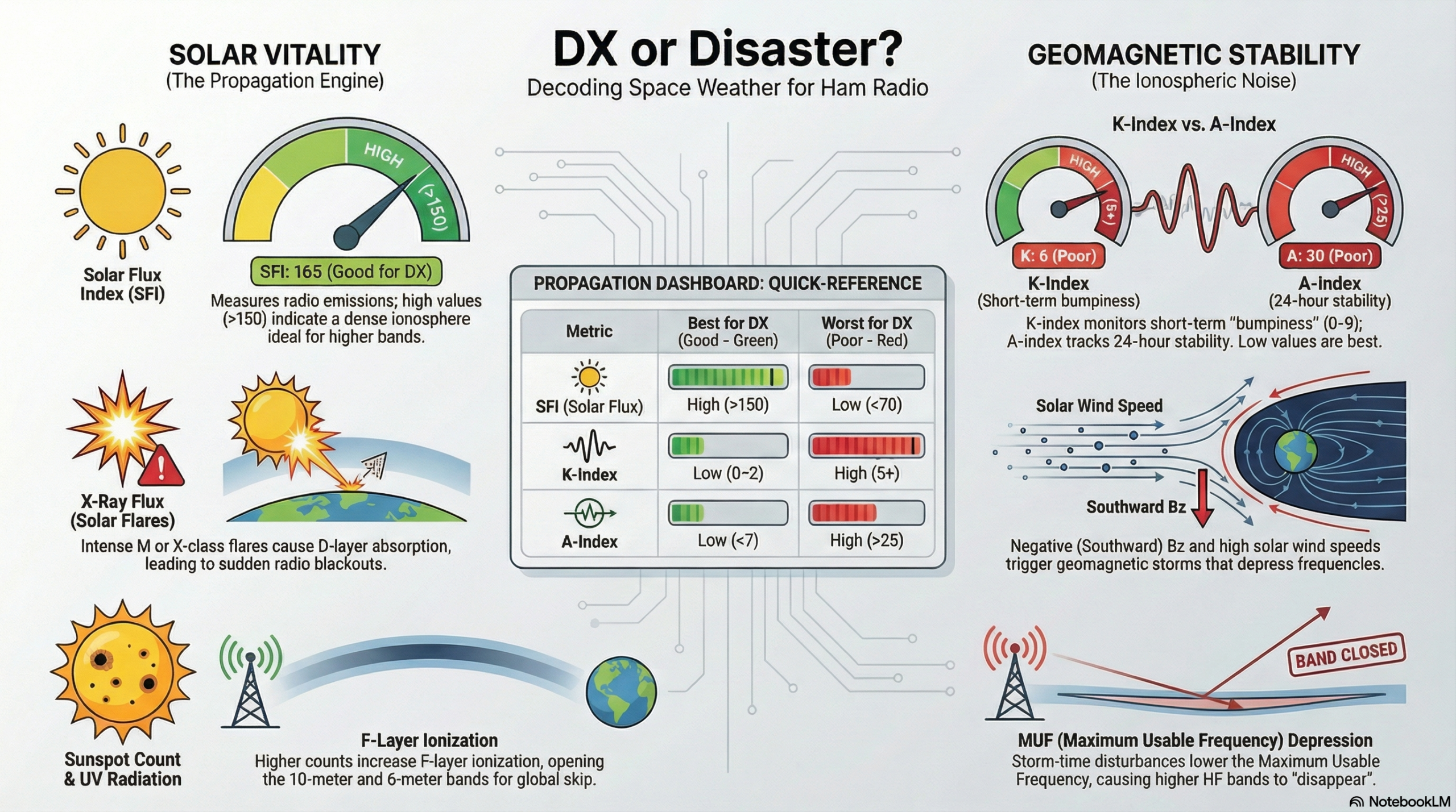
DX or Disaster? Space Weather Quick Reference
Space weather metrics and their impact on HF propagation.
Current Metrics
126
Solar Flux
104
Sunspots
19
A-Index
4
K-Index
371.0 km/s
Solar Wind
B4.5
X-Ray
S3-S4
Sig Noise
ACTIVE
Geo Field
NOAA Band Conditions
BandDaytimeNighttime
80 / 40mPoorFair
30 / 20mFairFair
17 / 15mFairFair
12 / 10mFairPoor
Source: hamqsl.com · 06:00 UTC
Generated daily at 6:00 AM ET · Station data: past 7 days · Space weather: past 30 days · Prepared August 04, 2026 at 06:00 AM ET · wspr.wb2mnfai.org · NOAA SWPC · Gloucester County Amateur Radio Club
© 2026 Gloucester County Amateur Radio Club. All rights reserved.
 Save as PDF

Archives

  • July 2024
  • November 2023
  • April 2023
  • March 2023
  • June 2022
  • July 2021
  • April 2021
  • March 2021
  • September 2020
  • September 2019
  • August 2019
  • July 2019
  • June 2019
  • December 2018
  • November 2018
  • October 2018
  • September 2018
  • August 2018
  • July 2018
  • June 2018
  • May 2018
  • April 2018

Categories

  • Balloon
  • Clubhouse Infrastructure
  • Digital Position Tracking
  • Raspberry Pi
  • Satellite Images
  • Satellite Operations
  • Satellite Telemetry
  • SDR
  • Uncategorized

Meta

  • Log in
  • Entries feed
  • Comments feed
  • WordPress.org
  • Home
  • Club Activities
    • WSPR Activities
      • Current WSPR & Band Report
      • Clubhouse WSPR Station Report
      • WSPR Network Monthly Reports
        • July 2026
        • June 2026
        • May 2026
        • April 2026
      • WSPR Field Day 2026 — Propagation Comparison
    • Satellite Activities
      • Saturday Clubhouse Satellite Opportunities
      • Weekly Satellite Report
      • Upcoming ISS APRS Activities
      • Upcoming ISS Viewing Opportunities
      • GOES 19 Weather Video
      • Current ISS SSTV Images
    • Recent DMR Activity
  • Clubhouse
    • Saturday Clubhouse Weather
    • The GCARC Clubhouse
    • Grounding Project
    • Networking Infrastructure
    • Work and Test Bench
    • Clubhouse Satellite Station
      • Satellite Rotator Controller
      • Satellite Station Remote Operation
    • SatNOGS Ground Station
    • Earth-Moon-Earth (EME)
    • Discovery Satellite Snooping Dish
    • GOES-19 Satellite Reception
    • Clubhouse Remote nRSP-ST Resource
    • Skunkworks GitHub Resource
    • ISS SSTV
    • NOAA Weather Fax
    • ADS-B
  • Technical Resources
    • Working Meteor Scatter at W2MMD
    • WSPR Network Resources
      • The TAPR WSPR Board for Dummies
      • Why Is My WSPR Signal 1500 Hz Off? — A Tale of Two Frequencies
      • GCARC WSPR Network — Project Description
      • GCARC WSPR Network — Technical Reference
      • GCARC WSPR Network — Band Selection Guide
      • GCARC WSPR Network — Analysis and Reporting
      • The GCARC WSPR Network — Member Q&A
    • DMR
      • What is a DMR Codeplug?
        • What Are DMR Channels?
        • What Are DMR Timeslots?
        • What is a Talkgroup in DMR?
        • What Are DMR Zones?
      • What is a DMR Hotspot?
      • Configuring DMR Hotspot for GCARC Talk Group
      • Connecting to the GCARC DMR TalkGroup with a Yaesu System Fusion Radio and a Hotspot
      • Using DM-1701 CPS Program
      • Open GD77 on Baofeng DM1701
      • Pi-based OpenGD77 Flasher: Bypassing Windows Driver Headaches
        • OpenGC77 Codeplug
    • Software-Defined Radios
      • Software Defined Radio Demystified
      • Installing an RTL-SDR on a Windows PC
      • SDR Tech Saturday Presentation January 2025
      • SDR Client Applications for Mac
      • Creating a PiAware Station to Track Airplanes
        • Installing PiAware Using the Prebuilt SD Card Image with Raspberry Pi Imager
        • Installing PiAware using Command Line Commands
    • Receiving ISS SSTV Images
    • Meshtastic
      • Getting Started with Meshtastic on 915 MHz
      • How to Join the GCARC Channel on Your Meshtastic Device Using a QR Code
      • Installing the Meshtastic CLI on a Windows PC
      • Window-Mounted 915 MHz Meshtastic Yagi Antenna Project
      • Meshtastic CLI Commands
    • Exploring Ham Radio Digital Modes: Packet Radio and WSJT-X
      • Packet Radio (AX.25) in Amateur Digital Communications
      • Exploring WSJT Digital Modes
    • BTECH UV-PRO Radio
      • Satellite Mode for the UV-PRO
    • TIDRADIO H3 Resources
      • TIDRADIO TD-H3 Transceiver: Comprehensive Briefing
      • Overview of Stock Firmware Menu System
      • Comparison of Stock TIDRADIO Firmware vs. nicFW V2 Firmware
    • Balloon Project
      • Balloon Launch – 2025-03-17
    • 3D Printed Projects
    • Tech Saturday Presentations
    • Receiving ISS HamTV
  • STEM Activities
    • STEM Club Weather
    • STEM Club Villanova Trip
    • STEM Club Satellite Pass Schedule
    • STEM Camp 2026
      • Calculator Skills — TI-84 Evo
  • Public Service
    • GCARC Planning Documents
      • Amateur Radio & Served Agency Integration
      • Building Served Agency Capability
      • The Ham Next Door
      • NIFOG Guide
      • AUXFOG Guide
    • GCARC Resources
      • Winlink VHF and HF Gateways
      • APRS Weather Reporting Station
    • AREDN Development
  • The Foundation
  • Blog
  • Contact

Gloucester County Amateur Radio Club 2026 . Powered by WordPress